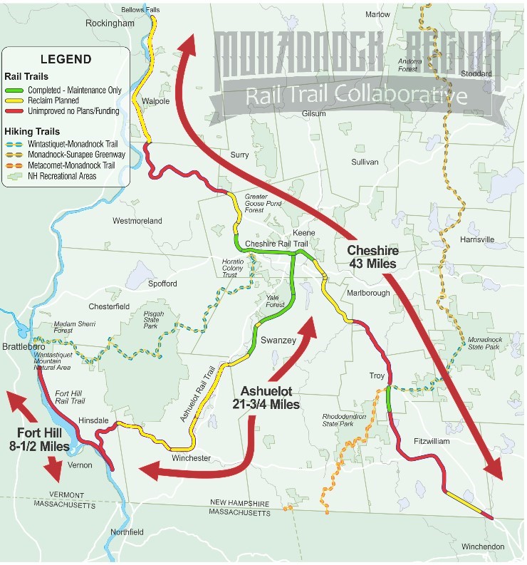
Figure 1: Monadnock Region Rail Trail Collaborative rail trail map showing the Cheshire (north and south), Ashuelot and Fort Hill rail trails. The map is color coded to indicate the level of reclaim that has been done to the trail, and these colors also correspond to general level of difficulty.
Monadnock Region Rail Trails
Cheshire County and Keene, NH have a rich railroad history that is still visible in four rail trails that run where the railroads once carried passengers and freight around the turn of the 20th century. Now these 73 miles of rail trails: Cheshire North and South, Ashuelot and Fort Hill Rail Trails, combine to make Keene a multi-day cycling destination. This statement comes with a caveat: while Monadnock Region trail organizations have done a great job of developing these trails, they are a large network with significant maintenance and reclaimation (clearing overgrown or blocked rail beds) challenges – and improvements are still planned and in progress. An excellent map is available (Figure 1) that provides insight into the trails and locations that riders of different abilities can enjoy.
Novice, family and road bike riders will be most happy on the green/completed trail sections. More advanced riders of hybrid bikes will find the yellow/reclaim planned sections accessible, and mountain bikers who are comfortable with more challenging trails should be able to complete even the red/unimproved sections. My wife and I rode the green sections during two easy day-visits last year. More recently, we spent a three-day weekend completing the yellow and red sections of all the trails. We rode the Cheshire South trail our first day, the Ashuelot and Fort Hill Trails our second day and the Cheshire North trail on the third. We used two cars to enable us to ride only one way, maximizing our downhill riding, and our total mileage for the long weekend was over 60 miles. Railroad history is visible in so many places on these trails and is also accessible to walkers or auto tourists interested in driving to view cut stone bridges and retaining walls, wooden covered bridges, rugged cuts through stone, abandoned rail signals, restored depots and painted murals on buildings. Though we rode the trails one at a time, for ease of organization, I will describe the sections in order of maintenance and accessibility, green sections first, yellow and finally the red sections. The reader who is a more adventurous cyclist (or tourist) will also be expected to read further in this article.
Cheshire North(west) Rail Trail
Easiest/Family Trail Sections
While some sources separate the Cheshire North and South trails in downtown Keene or not at all, there is a break in the trails of about a mile from the missing Route 101 crossing to Eastern Avenue (where there is limited parking), so for this article they will be split at this gap. Parking is available in downtown Keene, for example at the Ashuelot River Park on Island Street. The section through town heads east from Island Mill at 85 Island Street, connects with a bike/ped sidewalk on Emerald Street which turns left on School Street, then right to rejoin the trail on the original rail route along Gilbo Avenue. This eastern section is short (2 miles, one-way) and paved all the way to Eastern Ave. where you can turn around and retrace your route. Along this section you will pass the old depot and a mural on a nearby building that celebrates Boston & Maine Railroad history, Figure 2:
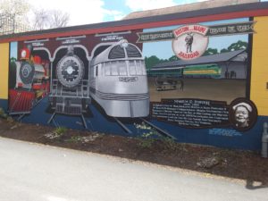
Figure 2: Downtown, located on the building opposite the old depot is a mural to celebrate the Boston and Maine RR, which at one time had 3 routes into Keene.
The northwestern section starts on Island Street just north of Island Mill, heads west over the North Bridge, and continues 2.2 miles to a trail parking lot. Though the surface becomes stone dust and eventually dirt, we found it to be easily rideable. Since it is also slightly uphill going out of town, it makes the return trip easier. Beyond the trail parking, at 2.78 miles the trail crosses Arch Street on a stone bridge that can be observed by stopping on the trail and scrambling down the slope on either side of the bridge to see the bridge entrances. Continuing to the northwest the trail gets a bit rougher (though surface improvements are planned for 2021) and uphill to the 6-mile mark at the Keene Recycling station. There the trail passes between cut stone retaining walls, Figure 3:
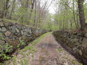
Figure 3: Stone from the cuts was used to build these cut stone retaining walls, another example of the stonemason’s craft along this trail.
and enters the Surry Cut, Figure 4, where the trail is rougher and wetter.
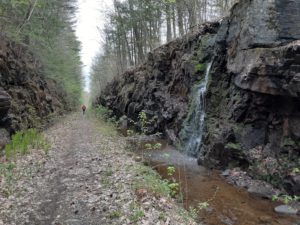
Figure 4. The stone walls of the Surry Cut are decorated with waterfalls in the spring and after a rain. This section of the trail has well-maintained ditches so the trail remains dry.
Families may want to stop biking near here and explore the cut on foot as far as they feel comfortable. In the spring, the cut is quite wet, with waterfalls cascading from its walls, which makes it a beautiful, cool spot on a warm day. Returning from here to downtown Keene makes for a reasonably challenging 12-mile round trip for families.
Tourists
You can drive through the stone arch bridge on Arch Street east of Park Avenue. You can also explore the Surry Cut and the cut stone walls on an auto tour if you are willing to walk (about 1 mile each way). The nearest trail head/gate is across from the Summit Winery on Route 12. Parking may be available next to the road at the gate, or you could ask at the Summit Winery if a purchase will allow you to park and walk across Route 12 to the gate across the road. The Surry Cut and stone walls are to the right (south) on the rail trail. The stone walls of this section of the cut are also used by rock climbers. Another impressive double stone arch bridge crosses Great Brook in Walpole, which can be seen by driving to Halls Crossing Road. Park near the rail trail crossing and walk down an overgrown trail on the north side of the road and to the east side of the rail trail. You’ll come to Great Brook in about 200 feet and if you look to the left you should see the brook passing through the double stone arches, Figure 5:
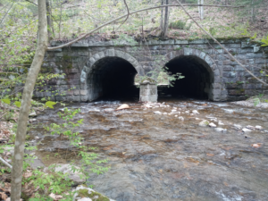
Figure 5. The double arch stone bridge north of Halls Crossing road allows the trail to span Great Brook. This eastern face of the bridge preserves its original stone facing, while the western side had to be reinforced with concrete, making it less picturesque.
More Advanced Riders
Beyond the Surry Cut, the trail heads downhill as it continues northward, so the return trip will be more challenging. Beyond the Surry cut at least two other cuts have been filled for road crossings and require the trail to detour around them, requiring more climbing than a typical rail trail. In addition, the maintenance of the ditches beyond the summit is not yet complete, so especially in cut regions the trail can become wet with mud puddles in spring or after rains. This continues to Blackjack Crossing Road, where the trail is not yet reclaimed all the way to Halls Crossing Road. It is best to detour onto Route 12 and Halls Crossing Road for 1.5 miles and rejoin the rail trail there. The trail continues to River Road in Walpole where it is recommended to turn around. The town of Walpole is currently applying for grants to reclaim the trail all the way into town. Just north of Halls Crossing Road, the trail passes over Great Brook on a double stone arch bridge; directions to walk to see it are described above for tourists.
Ashuelot Rail Trail
Easiest/Family Sections
The starting point for the Ashuelot (say it like a local: “Ash-we-lot”) Rail Trail is located at Gilbo Ave. and School Streets where it heads south, jogs west along Emerald Street and then heads south toward the South Bridge crossing over Rt. 101. This trail surface is mostly hard packed stone dust, and very rideable for 5 miles until you reach Pine Street in West Swanzey, where improvements are in progress. Along the way you can enjoy the greenery of Keene State College and its sports fields located south of Rt. 101. At 3.3 miles you reach Sawyer’s Crossing Road where a left turn takes you to Cresson Covered Bridge over the Ashuelot River, Figure 6:
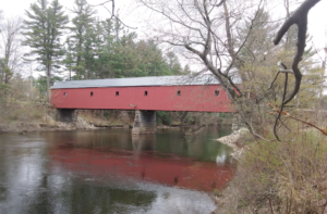
Figure 6. Cresson Covered Bridge across the Ashuelot River at Sawyer’s Crossing Road is at the 3.3 mile marked on the Ashuelot Rail Trail from Keene and is a cool place for a rest stop on your ride, as well as a beautiful stop on a circle tour of covered bridges in the area south of Keene
When families reach Pine Street in West Swanzey, a half-mile extension will take them to Denman-Thompson Covered Bridge, an open lattice design. To get there, they should continue along Pine Street, bear right onto Railroad Street, and follow it to Main Street, where a right will take them across the bridge. This makes for a 10-11 mile round trip which could be enough for families and novice riders.
Tourists
Cheshire county boasts an abundance of covered bridges, adjacent to the Ashuelot Rail trail. These include Cresson Covered Bridge at Sawyer’s Crossing. Beside it is a parking area and a cool spot to take in the views of the bridge. Just two-tenths of a mile south of Sawyer’s crossing the rail trail crosses a trestle bridge over the river. For auto tourists, it is manageable to walk from the parking area at Cresson Bridge to the trestle to see it as it crosses the river. There are several other covered bridges nearby: Slate, Carlton, Denman, Coombs and Ashuelot Covered Bridges. Tours of these bridges are described in multiple articles online:
https://www.nhmagazine.com/road-trip-keene-color/
More Advanced Riders
Beyond West Swanzey the Ashuelot Trail surface begins to become more sandy, grassy, rougher and wet, with puddles making passage more difficult. Experienced riders on hybrid or mountain bikes will find it an interesting challenge. Along the way the trail passes the Ashuelot Depot and the Hinsdale Depot which is now a private residence. The highlight of the rest of the route is the whitewashed Ashuelot Covered Bridge, Figure 7:
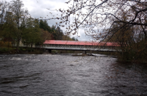
Figure 7. The beautiful white Ashuelot Covered bridge is right adjacent to the rail trail in the town of Ashuelot.
The Ashuelot river begins to drop more rapidly here providing a wilder character than the slower sections upstream. Because this section becomes steeper downhill going south, we rode one-way. If you return be prepared for the climb on your return to the town of Ashuelot.
Cheshire South Rail Trail
Easiest/Family Sections
For families, the Cheshire South Trail presents some challenges because it has not been improved as much as the trails mentioned earlier. There is still a 3-4 mile section that should be easy enough for a family ride. This starts at the Depot in Troy at Water and Depot Streets, where ample parking is available. The trail is slightly uphill as you head south past the Depot, and in 2.1 miles reaches Rockwood Pond. Continue beyond this to where the trail meets Rhododendron Road. At this crossing the trail begins to head downhill toward Fitzwilliam and on to the Massachusetts border, so returning beyond Rhododendron Road will require a climb. Better to return to the Depot for a 6.6 mile ride. If your crew still has energy when you reach the Depot, continue 0.4 miles north on the trail through Troy, look on your left for the sign to Dragon Palace, hike up to the snowmobile trail to the parking lot, and try Dragon Palace, the Troy Pizza Barn or a convenience store to reward them with a meal or snack. Beyond this the trail becomes downhill toward Keene and is rougher, more suitable for advanced riders.
Tourists
The Cheshire South trail has restored Depots in Fitzwilliam and in Troy, several stone bridges, and rock cuts that are possible for a tourist to see by car. On the north end at Route 101 is a parking area for auto tourists to stop and view the Stone Arch Bridge, Figure 8:
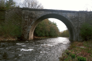
Figure 8. The Stone Arch Bridge is located on the south side of Route 101 heading into Keene from the east side. It is visible from Rt. 101, but for best viewing it is necessary to stop and walk along the rail trail or along the river.
***Warning: The Stone Arch Bridge has not been fully restored and so it has no railings to keep you or your children from falling 60 feet down into the river. Please keep away from the edges and either don’t bring your children here, or keep a hand on them at all times!*** The bridge itself doesn’t really provide a view of the arch, and requires a scramble down rather steep banks on either end, which can be done, since this is how this photo was taken. If you are not the “scrambling sort”, you can walk east from the parking area on the side of Rt. 101, and when the shoulder narrows, stay to the right behind the guard rail, separated from traffic for about one-hundred feet until the arch comes into view behind you on the right.
Along this trail section are two other stone arch bridges, the first is over Webb Depot Road which exits from Rt. 12, turns to dirt and passes beneath the one-lane stone bridge, Figure 9:
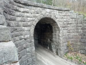
Figure 9. Stone Bridge over Webb Depot road, which exits Rt. 12 south of Keene.
The second, over the Ashuelot River, is at 270 N. Main St. (Rt. 12) in Troy can be seen from the road or by turning on a side road just south of the Ashuelot River to get out of your car for a better view, Figure 10:
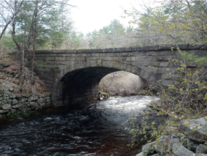
Figure 10. Stone Bridge over the Ashuelot River visible from Rt. 12, at 270 North Main Street, Troy, NH.
Intermediate Riders
For riders wanting to ride the intermediate section of this trail, I suggest you start at the southern trailhead, located at State Line Circle in Fitzwilliam, and ride north at least to the crossing of Rhododendron Road at 7.4 miles. Your return is all downhill to the beginning for a 15 mile round trip. If you still have energy when you get to Rhododendron Road, continue as far as the Troy Depot or the Pizza Barn for lunch and then return, for a total round trip of 22 miles. You might find a few puddles on this route, but you should be able to ride through or walk around them. The southern section between Turnpike Road and Templeton Turnpike is planned for rehabilitation in 2021, so it should improve.
More Advanced Riders
While it is possible to continue south on Eastern Avenue and Marlboro Street parallel to the overgrown railroad grade, this route to rougher sections of the Cheshire South trail currently requires an “at-grade” crossing of Rt. 101, and while possible this is not recommended for safety’s sake. Plans are in the works in the next 5 years to reclaim the railroad bed between Eastern Avenue and Rt. 101 and build a bike/ped bridge over Rt. 101 to reconnect the stone arch bridge. With the track record Monadnock Region Trail Organizations have in building two bike/ped bridges over busy routes (Rt. 101 and Rt. 9), one can believe they will get it done. For current access to the south portion of the trail, a dirt parking area is available on the south side of Rt. 101 at the Cheshire Stone Arch Bridge and you can start from here. Crossing this bridge and heading south the trail becomes significantly rougher, though it can be handled by experienced riders with mountain bikes. The route is a continuous climb for 11 miles gaining 640 feet on the way to Rockwood Pond in Troy, so it is more easily ridden (one-way) from south to north since there is parking at Rockwood Pond or at the Troy Depot. Trail work is planned in 2021 to clear drainage ditches between Joslin Station Road and Webb Depot road, which will dry out the wet spots in the deep cuts in this section and make the trail more easily passable.
Fort Hill Rail Trail
Tourists
Tourists should be able to see the “License Plate House” at 414 Northfield Road, Hinsdale, Figure 11, by just driving by it.
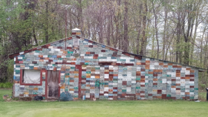
Figure 11. The “Licence Plate House”, marked as such on Google Maps, on Rt. 63, 414 Northfield Road, Hinsdale. It is a private residence, but can easily be seen from the road. Just to the right of the rake head, the plate reads “BIKING”
There is a stone bridge at the Hinsdale Town Walking Park that can be viewed and crossed on the trail with a short, easy hike from the parking area marked with a picnic table, described below. With a longer, one-mile hike from A1 Pizza & Grill, down the cut trail (location given in the following Advanced and Intermediate Riders section), and north along the rail trail, the trestle bridge across the Connecticut River can be viewed, Figure 12:

Figure 12. The trail gets overgrown with some washouts in the last mile before the bridge, but the rider or hiker that perseveres is treated with this view of the trestle across the Connecticut River.
Intermediate and Advanced Riders
Though not yet fully reclaimed, the Fort Hill Rail Trail begins at a shared trailhead/parking area near the south end of the Ashuelot Rail Trail (just south of the “License Plate House”) and runs north along the Connecticut river providing some scenic views. We added it to the end of our longest day, riding it one way toward the north after we finished the Ashuelot trail going south. Since we had ridden the “easy” 5-mile section of the Ashuelot trail on an earlier trip, our mileage to complete both trails was only about 26 miles. The challenge is finding a place to park at the north end of the trail, as it dead ends at the railroad bridge over the river, which is not passable. From there we backtracked to a trail we could push our bikes up so that we came out onto Rt. 119, just north of the TNT Fireworks center. The trail joined the road on the north side of a clearing north of the A1 Pizza & Grill on Rt. 119 (987 Brattleboro Road). There is also parking at a picnic area 2 miles south of TNT Fireworks, at the Hinsdale Town Walking Park, from which a walking path leads to the rail trail, and joins it at the point where it crosses Ash Swamp Brook over a stone bridge.
Text and Photos by Richard Westhoff